Remains of Pessinus were first discovered by Charles Texier, who visited Ballıhisar in 1834. He left an assumed drawing and restitution plan related to the remains of this ancient city. Karl Humann, who visited the village in 1882, drew a sketch of ancient structures, which were visible back then. Excavations in the area finally started in 1967 by a team under the leadership o Pierre Lambrechts from Ghent University. The purpose of this excavation was explained as to discover the infamous Cybele Temple, which is frequently mentioned and described in works of ancient authors. Lambrechts continued excavations until his death in 1973. John Devreker from Ghent University restarted excavations in 1987 and continued until 2008. After him, a team under the leadership of Gocha Tsetskhladze from the University of Melbourne continued excavations.
Ballıhisar is located on a valley with an elevation of 950 m, surrounded by hills of the Central Anatolian Plateau and leans against Sivrihisar mountain chain. Although this area is very arid today, there are signs of a higher water base back in antiquity. Pessinus lies on the River Gallos, which is a dry channel today and only fills during floods or heavy rain periods. It is still a question whether this is an antique river bed, because it seems possible that the river changed its flow multiple times in antiquity.
There are still many questions regarding the area despite of excavations efforts for over 30 years and the Cybele Temple has not been discovered yet.
According to Ancient Greek and Roman authors, Pessinus was founded by the semi-mythological Phrygian ruler King Midas around 8th century BC as the sacred city of the Cybele cult.
The city which hosted the main temple of Cybele later became a temple city. The Attalos Dynasty of Pergamon rebuilt the Cybele Temple after conquering the city and added porches made from white marble. A cult stone rumored to have fallen from the heaven was carried from Pessinus to Rome in 3rd century BC and placed in the Temple of Victory (191 BC) on the Palatine Hill. When Augustus constituted the state of Galatia in Central Anatolia around 25 BC, Pessinus was under the rule of Rome. Emperor Julian prayed here in 362 AD.
The earliest evidence of settlement in Pessinus dates back to 1600 BC, a piece of pot from Old Hittite Kingdom. The piece was found in the main excavation area called “the Temple Area”. Also, an object containing ashes was found in this area as well. Radiocarbon dating of these findings show that these date back to 1500 BC. These findings show that the settlement in the area started around mid-2nd millennium BC.
A Phrygian pin and stone wall pieces and some pots from the Middle and Late Phrygian periods (4th and 6th century BC) were found in the same pit. Phrygian stone graves, front facades and other visible remains of the Phrygian settlement were discovered in four different locations 8-14 km north of Ballıhisar, which is referred to as the Pessinus area. The most important among these is a Phrygian burial chamber and a three-step altar, which are located 8 km from Pessinus and date back to 6th to 8th century BC.
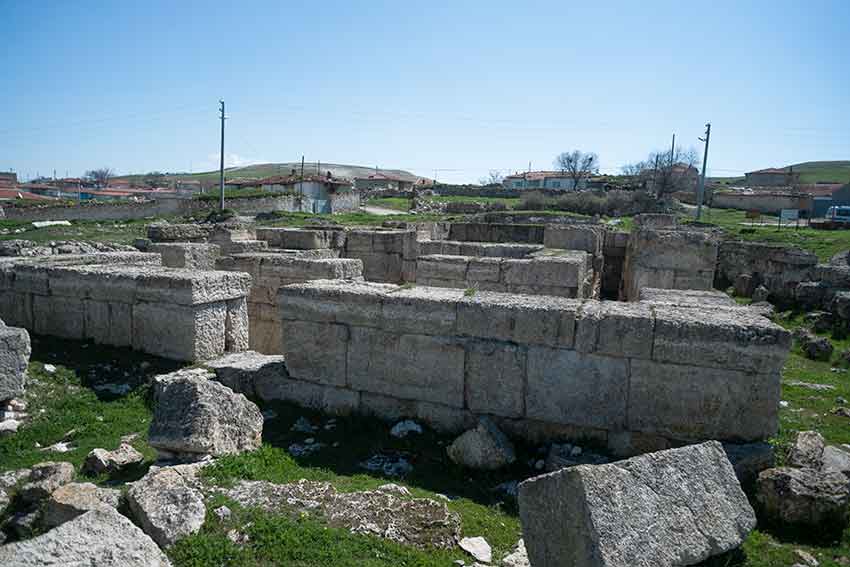
In addition to remains of houses from Late Hellenistic, Roman and Byzantine periods in various parts of the modern village, workshops and a Byzantine church and castle were found during excavations. Local stones and marble were used in all of these structures. A marble quarry was found about 12 km from İstiklalbağı. This area located in a large valley surrounded by hills was used as a graveyard in antiquity. Many graves were found here and some of them were partially excavated. Most of the graves dating back to 3rd to 2nd century BC are marble sarcophagi containing valuable objects.
In the hill facing north in the eastern part of the modern village, there is a theater with a capacity of 8000 and believed to be built or restored in Roman Emperor Hadrian’s era (117-138 AD). Marble sitting areas were completely removed by locals in the last two centuries.
The wall of a monumental building lies in a visible manner between the Excavation House and the Research Center on the hill overseeing the village (and the excavation area). This building is described as a “Late Roman Era building”. The area was partially excavated in 1960s.
Hamamtepe near Karacaören which is about 8 km southeast to Pessinus is an area located on top of a hill with an elevation of 1600 m. Fort walls and remains of monumental buildings probably dating back to the Hellenistic Period are clearly visible.
There is a large reservoir/pool carved out of rock in the middle of the area. Pots obtained from the surface date back to various eras from the Early Iron Age to the Ottoman Era. It is thought that the city transformed from a temple city to into a Greek-style polis beginning from 1st century BC and developed into a well-known Greco-Roman city in Anatolia. In this period, monumental structures such as the temple complex, gyms, theaters, and the Stoa were built. Pessinus also started to issue its own coins.
The boundaries of Pessinus are still not known for certain. One of the main duties of the team consisting of students and experts from Australia, Turkey and nine other countries under the leadership of the University of Melbourne is to draw the boundaries of the city. On the other hand, drawing a map of the findings and comprehensive surveys around Ballıhisar helped make certain estimations. It is believed that the city had an area of 19 ha as a settlement before the Hellenistic Period and an area of 88 ha as a settlement in the Roman Period together with an area of 18.5 ha for the graveyard.
It is also difficult to estimate the surface area of lands controlled by Pessinus. This area is believed to be quite large in the Late Hellenistic Period, the Roman Period, and the Ottoman Era. This area is bordered by Dindymos / Günyüzü Mountain to the north and the east and the Sangarios River to the south and west. It covers Babe Çeşme (2 km north to Sivrihisar) and İstiklalbağı, Dinek, Çaykoz and Karacaören (an area of 7-11 km in an arc to northeast and southeast from Ballıhisar).
A boundary stone indicates that İstiklalbağı was within boundaries and an imperial letter shows that the area covered Tekören. Monuments on the upper part of Dindymos could not be linked with Pessinus with certainty. However, this link will be established if associations with Cybele can be found.
In spite of years of studies, remains of fort walls surrounding Pessinus could not be found. This should not be surprising: Phrygia had other cities without walls as well, such as Aizanoi. Pessinus was defended by watchtowers instead of fort walls thanks to its topography. It was possible to surround and protect the city with such watchtowers because it was located in a deep valley. The team from Melbourne and geophysics experts in the team detected six or seven possible watchtowers. In 2011, excavation efforts started for a Late Roman – Early Byzantine castle which discovered in geophysics surveys (Figure 13) of the previous year (Sector S) (Figure 12). Pessinus crosses the Roman road from Amorium to Germa in north-south direction. Some parts of the road remained to this day and are clearly visible especially near İstiklalbağı.
Tekören continues to be the focal point for the Melbourne team as it was for the Ghent team. Surface examinations were carried out with geophysical surveys. Pots found here date back to various eras from the Bronze Age to the Ottoman Era. Geophysical surveys showed remains which are likely to be ovens in some areas and numerous 10 x 5 m rectangular structures.
Very interesting findings were obtained in the vineyard area, the outgrowth of the high plateau about 1.5 km northeast to Ballıhisar and the point where two flows of the River Gallos running through the village meets. As well as marble architectural details, numerous pieces of pot were found here. Most of these are pitos and tiles from the Late Roman / Early Byzantine periods. Geophysical surveys here revealed various well-protected rectangular structures.
Surface examinations were conducted at Harman Yerleri, about 500 m southwest of the modern village center, and at Tütücünün Ağılın Tepe, about 3.5 km further out in the same direction. Both places yielded a large quantity of Roman pottery on the surface as well as some fine marble architectural details and marble blocks. Rescue excavations at Gediközü Mevkii, 5 km west of Ballıhisar, showed that this area was a graveyard dating back to the Roman Period.
Thus, although Pessinus and its surroundings continue to pose many unanswered questions, it is proving to be a very important city in Central Phrygia – a fact reinforced by some 200 inscriptions from the site and neighboring territories, notably eight private and secret letters received by the High Priest of Cybele at Pessinus from the Attalid kings in the 2nd century BC.


